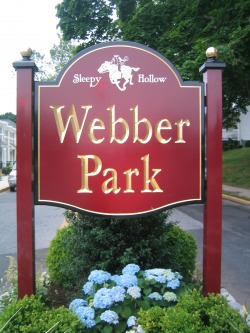
History of Webber Park
Originally called The Village of Beekmantown, “north of Tarrytown” - the area of Sleepy Hollow that we know today was once owned by Gerard and Cornelia Beekman, who used the land for farming. When Mr. Beekman died in 1822, Cornelia Beekman was want for financial security. She decided to offer the property for sale, broken into village lots. By 1839 the lots were sold and released to the Town of Mount Pleasant. The center of the property area is marked by Beekman Street (now Avenue) running from Post Road (route 9) to the Hudson River. The surrounding main fares were Cortlandt, Clinton and Depeyster Streets. New Broadway, (formerly ‘Jones Avenue’ until 1875, and also marked on a map from 1891 as ‘North Broadway’) is the main street into Webber Park, leading to Douglas Park.
It is around 1870 that residents began to refer to their village as North Tarrytown, likely due to the incorporation of Tarrytown to Greenburgh; residents began the process of seeking status with Mount Pleasant.
Hutchinson, Lucille and Theodore. “The Centennial History of North Tarrytown”, copyright 1974, ref maps: p.179,181
Webber Park – This 1926 residential development is named for John Webber, a Sleepy Hollow (North Tarrytown) village attorney. When John Anderson died in 1880, Webber became an executor of his estate. In 1886, Webber purchased the Anderson property. Webber Park lies, roughly speaking, between Broadway and New Broadway.
Reprint with permission from “The Place Names of Historic Sleepy Hollow and Tarrytown”, by Henry Steiner; ref. p.151
History of Douglas Park
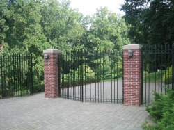
Main gate to Douglas Park
The Douglas Estate - Local maps of the 1870’s show the Douglas estate located immediately north of the Thayer residence (Edgewood) and east of Gorey Brook Road.
Long View – was the name of the Douglas estate on Prospect Hill. According to Hutchinson [HU], the house had an observatory with views of the countryside. Scharf [SC] describes it as the “country seat of Henry L. Douglas”.
Prospect Hill – has also been known as Cedar Hill and Jones Hill. Long View, the thirty-eight-acre estate of Henry L. Douglas, stood n Prospect Hill east of the Old Croton Aqueduct and south of the G.S. Rice estate in 1891. Douglas first came to this area in 1868. He had been successfully engaged in business in San Francisco from 1851 to 1857. The Douglas Estate also bordered that of S.T. Thayer, stockbroker and poet. Douglas Park is dedicated to the brother of H.L. Douglas, John W. Douglas (d. 1883). The Tarrytown Argus [AR] of September 29, 1883, noted the death of John W. Douglas. When H.L. Douglas died on May 6, 1887, he left two sons, Archy and Percy, and a daughter, Catherine Waldo Douglas.
The name Prospect Hill was apparently in use before the H.L. Douglas tenure; see the map of 1864 [M62]. Scharf suggests that the hill was used for reconnaissance by Washington and that it was a lookout for local Indians prior to European settlement.
Douglas Park - was named for stockbroker John Douglas (d. 1883). John Douglas was the brother of Henry L. Douglas, who owned the adjoining land in the 1880’s. The Douglas mansion stood on the hill above the park. According to Hutchinson, Henry L. Douglas occupied the mansion from the 1880’s until about 1900. The Douglas estate was inherited by William Harris Douglas, who owned it until the 1940’s. William Harris Douglas, a former congressman, acquired land from the John Webber estate. He gave the parcel to the Village of North Tarrytown on June 16, 1939. It was dedicated as Douglas Park on June 6, 1942. Douglas was quoted as saying, “I just thought it would come in nice for the people of North Tarrytown…”
The old Croton Aqueduct and the Pocantico River border the seventeen-acre park, east and west. The park features a small playground, picnic sites overlooking the Pocantico River, and dramatic, steep terrain descending to the river. The main access is from New Broadway.
Reprint with permission from “The Place Names of Historic Sleepy Hollow and Tarrytown”, by Henry Steiner; ref. p. 47-48; p. 76; p. 111. ref. [HU] Hutchinson, Lucille and Theodore. “The Centennial History of North Tarrytown”, copyright 1974.
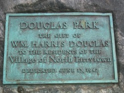 Plaque at entrance |
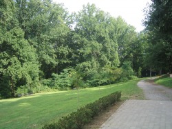 Douglas Park, view north |
